Modoc County Webcams
Live views of roads, mountains, and approaches to Northeast California
Live webcams in and around Modoc County, collected in one place. Useful for checking road and weather conditions on the way in, watching the backcountry, and occasionally spotting smoke from a distant fire.
Images refresh about every minute. A frozen or black image usually means maintenance, dusk/night, or snow on the lens — try again later or follow the source link.
Camera Locations
Pins mark approximate camera locations. Markers with arrows are fixed cameras — the arrow shows roughly which way they're aimed. Plain blue pins are pan-tilt-zoom cameras that can look anywhere. Click a marker for details.
Coordinates and aim directions are approximate, derived from public camera descriptions. Please use the source links for authoritative views.
Modoc Highway Cameras
Caltrans cameras on the two main mountain crossings into Modoc. Especially useful in winter, when Cedar Pass can pick up serious snow.
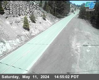
Cedar Pass — SR-299
On State Route 299 about a mile west of Cedar Pass, between Alturas and Cedarville. The pass tops out at 6,305 feet and is the main winter crossing into Surprise Valley.
Open at Caltrans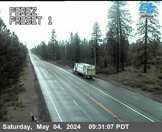
Perez (Tionesta) — SR-139
On State Route 139 at the Perez Agricultural Inspection Station, between Canby and the Oregon border. This is the camera Surprise Valley locals call "Tionesta."
Open at CaltransMore Caltrans District 2 cameras (Lassen, Shasta, Siskiyou) are listed at dot.ca.gov — District 2 Cameras. For statewide road conditions, use Caltrans QuickMap.
Modoc Backcountry & Wildfire Cameras
UC San Diego's ALERTCalifornia network operates pan-tilt-zoom cameras across California's wildlands for early fire detection. The Modoc cameras sit on high points across the county and capture full 360° panoramas every couple of minutes. Each panorama below is the camera's most recent sweep, fetched live from ALERTCalifornia.

Blue Mountain (Modoc) — Live 360° Panorama
Mountaintop camera in northern Modoc, with sweeping views across the central plateau. Pan-tilt-zoom with near-infrared at night. (A second co-located camera is available from the ALERTCalifornia console.)
Open at ALERTCalifornia
Sugar Hill — Live 360° Panorama
High ridge north of Davis Creek, looking out across Goose Lake and the upper Modoc plateau. (A second co-located camera is available from the ALERTCalifornia console.)
Open at ALERTCalifornia
Devils Garden — Live 360° Panorama
On the Devils Garden plateau in the Modoc National Forest — high, open country with long sightlines across the plateau and toward the Warners. (A second co-located camera is available from the ALERTCalifornia console.)
Open at ALERTCalifornia
Round Mountain (Modoc) — Live 360° Panorama
High-elevation camera in western Modoc, near the Siskiyou line, offering a different vantage on the Modoc backcountry. (A second co-located camera is available from the ALERTCalifornia console.)
Open at ALERTCalifornia
Likely Mountain — Live 360° Panorama
High peak above the town of Likely in southern Modoc, on a long-time fire-lookout site. Useful for wildfire smoke spotting across the South Warner Wilderness and the Modoc/Lassen line. (A second co-located camera is available from the ALERTCalifornia console.)
Open at ALERTCaliforniaTo explore the full network or scrub the timelapse, visit the ALERTCalifornia map centered on Modoc. Camera names and IDs occasionally change as the network is upgraded; if an embed shows a placeholder, the camera may be offline or have been renamed.
Approach & Adjoining-Area Cameras
These cameras don't sit inside Modoc County, but they're useful in three ways: checking road and weather conditions on the way in, gauging snow on the surrounding mountains, and occasionally spotting a smoke plume from a distant Modoc fire on the horizon. Each card below is honest about where the camera physically sits and what it actually shows.

US-395 at Lakeview, OR
Where: Lake County, Oregon, in downtown Lakeview — about 17 miles north of the Modoc line at New Pine Creek. What it shows: US-395 through Lakeview, not Modoc. Useful for checking weather and road conditions on the most common northern approach to Alturas.
Open at TripCheck
OR-140 at Warner Mountain Summit
Where: Lake County, Oregon, on OR-140 east of Lakeview, well north of the CA border. What it shows: the Oregon side of the divide between Goose Lake and Warner Valley — not Modoc directly. The Warner Mountains continue south from here into Modoc, so it can be a useful early-season snow gauge for the range.
Open at TripCheck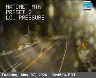
Hatchet Mountain — SR-299
Where: Shasta County, on SR-299 at the summit east of Burney, ~70 miles west of Adin. What it shows: the highway over the Hatchet Mountain summit — not Modoc itself. Worth a glance if you're approaching Modoc from Redding via SR-299, which is the main western route in.
Open at CaltransLava Beds National Monument Visitor Center
Where: Siskiyou County, at the Lava Beds visitor center (~4,700 ft), just west of the Modoc line. What it shows: a wide northward view over the Lava Beds wilderness and Tule Lake basin — mostly Siskiyou and Klamath Co., Oregon. Modoc sits to the east, behind/beside the camera, so it doesn't show Modoc directly, but it's a useful weather-and-smoke view for the western edge of the region.
View live →Don't see a camera you'd expect? There are very few public cameras in remote NW Nevada (Washoe County) or in the high country of Lassen and Siskiyou facing toward Modoc. If you know of one we've missed, the contact link is at the bottom of the page.
Frequently Asked Questions
About These Cameras
None of the cameras on this page are operated by Visit Modoc — we're just collecting public feeds in one place. The actual sources are:
- Caltrans District 2 — Cedar Pass and Perez highway cameras
- ALERTCalifornia (UC San Diego) — Blue Mtn and Round Mtn wildfire cameras
- Oregon TripCheck (ODOT) — US-395 Lakeview and OR-140 Warner Mountain Summit
- National Park Service — Lava Beds National Monument visitor center
For a broader view of the region, the Surprise Valley Chamber of Commerce also keeps a useful weather and roads page.